Sri Lanka’s 2012 Census of Population and Housing categorised only 18.2% of the Lankan population as being urban. However, that figure is highly misleading because we currently use a narrow definition.
Currently, only those living in Municipal Council (MC) or Urban Council (UC) areas are considered urban. However, some Pradeshiya Sabha areas (the next local government unit) are just as urbanised.
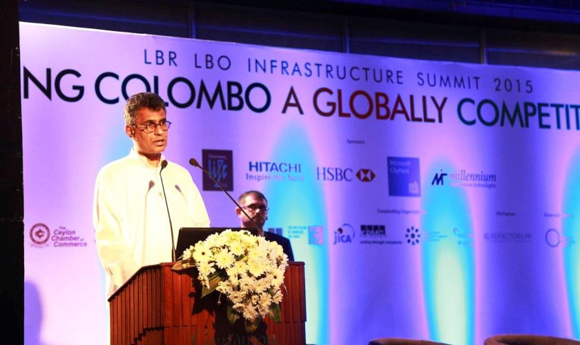
At the recent LBR/LBO Infrastructure Summit 2015 held in Colombo in early November, Minister of Megapolis and Western Development Champika Ranawaka took on this myth head on. He argued that Sri Lanka’s urban population share is probably as high as 48% — which is two and a half times higher than the current figure.
His concern: misconceptions such as this distort the country’s policy decisions on infrastructure planning and urban development.
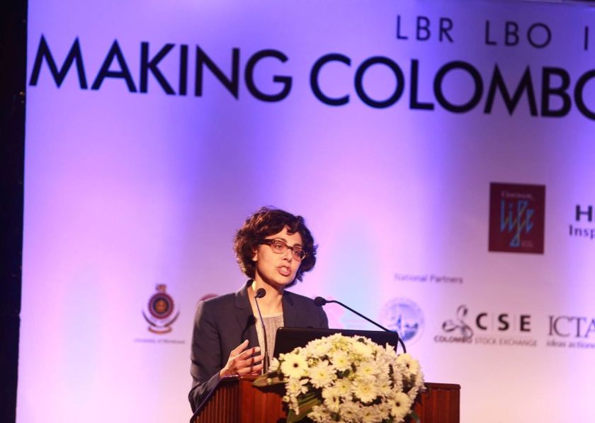
The World Bank’s global lead for urban development strategies, Sumila Gulyani, who spoke during the opening session, agreed with the Minister’s contention of nearly half of Sri Lanka’s population having already become urban.
I discuss the matter in this week’s Ravaya column, (appearing in issue of 29 Nov 2015).
I covered similar ground in an English Op Ed published in Daily Mirror on 12 Nov 2015: Let’s Get Real about Sri Lanka’s Urbanization!

නගර යන සංකල්පය ඉතිහාසයේ මතුව ආයේ පහසුකම් හා අවස්ථාවල සංකේන්ද්රනයක් හැටියටයි. එසේම වඩාත් වාණිජ සබඳතා හා සංස්කෘතික කටයුතු සිදු වන ප්රදේශ ලෙස ද අප නගර දකිනවා. භෞතික ගොඩනැගිලි හා මහාමාර්ගවලට වඩා නගරවල වැදගත් සාධක වන්නේ මේවායි.
නගර බිහි වීම ශිෂ්ටාචාර පරිනාමයේ එක් අවස්ථාවක්. එයට උදාහරණ මොහන්ජොදාරෝ, ඇතන්ස්, රෝමය මෙන් ම සහස්රයක් මෙරට රාජධානියව පැවැති අනුරාධපුරයත් දැක්විය හැකියි. කලාකරුවන්, චින්තකයන්, විද්යාඥයන් බොහෝ විට බිහි වන්නේ නගරවල සමාජ-ආර්ථික තෝතැන්න හරහා.
මුලදි ග්රාමීය ලක්ෂණ පවතින ප්රදේශවල යටිතල පහසුකම් ටිකෙන් ටික දියුණු වී, නාගරික පෙදෙස් බවට පෙරැළීම නාගරීකරණය (Urbanisation) යයි හැඳින්වෙනවා.
බහුතර පිළිගැනීම නම් මෙය රටක් දියුණු වීමේ ලක්ෂණයක් බවයි. එයින් අදහස් කැරෙන්නේ ගම් නොදියුණුය යන්න නොවෙයි. නූතන පහසුකම් සහිතව, ආයාසය අඩු කර ගෙන ජීවත්වීමට අද කාලේ බොහෝ දෙනකු කැමතියි.
ශ්රී ලංකාවේ නාගරික ප්රදේශ කොපමණක් ඇත්ද? ජනගහනයෙන් කිනම් ප්රතිශතයක් නාගරික ප්රදේශවල වාසය කරනවාද?
මේ ගැන යම් ව්යාකූලතාවක් හා විවාදයක් තිබෙනවා. මෙගාපොලිස් හෙවත් මෙගා පුරවර වෙත රට යොමු වන මේ මොහොතේ මෙය නිරවුල් කර ගැනීම ඉතා වැදගත්.
2012 අවසන් වරට කළ ජන සංගණනයට අනුව මෙරට ජනගහනය 20,359,439ක් (මිලියන 20.36) වුණා. එයින් නාගරික යයි සැළකෙන ප්රදේශවල වාසය කළේ 18.2%ක් පමණයි.
එහෙත් මෙය මුලා කරවන සුළු තරම් කුඩා ප්රතිශතයක් බව සංගනනය කළ ජනලේඛන හා සංඛ්යාලේඛන දෙපාර්තමේන්තුවම ප්රසිද්ධියේ කියනවා.
2012 සංගණනයේ ප්රතිඵල කැටි කැරෙන හා විග්රහ කැරෙන නිල ප්රකාශනයක දෙපාර්තමේන්තුව මෙසේ කියනවා. ‘දැනට මෙරට නාගරික ප්රදේශ ලෙස සැලකෙන්නේ මහනගර සභා (Municipal Councils) හා නගර සභා (Urban Council) බල ප්රදේශ පමණයි.
එහෙත් 1987 වන තුරු සුළු නගර සභා (Town Councils) බල ප්රදේශ ද නාගරික ලෙස සළකනු ලැබුවා. 1987දී ප්රාදේශීය සභා පිහිටුවීමත් සමග ඒවා අහෝසි වූ අතර, සියලූම ප්රාදේශීය සභාවල බල ප්රදේශ ග්රාමීය යයි පරිපාලන වශයෙන් පිළි ගැනීම ඇරැඹුණා.’
මේ අනුව එතෙක් නාගරික යයි සැලකූ සමහර ප්රදේශ එක රැයින් ග්රාමීය ලෙස නැවත වර්ගීකරණය වූ බවත්, එතැන් පටන් මෙරට නාගරික ප්රදේශ හා නාගරික ජනගහන ප්රතිශතය අඩුවෙන් තක්සේරු කිරීම දිගටම සිදු වන බවත් දෙපාර්තමේන්තුව කියනවා.
මේ විසමතාව සමහර විද්වතුන් කලෙක සිටම පෙන්වා දෙනවා. මොරටුව සරසවියේ නගර සැලසුම් පිළිබඳ මහාචාර්ය ඈෂ්ලි එල්.එස්. පෙරේරා එයින් ප්රමුඛයි.
‘1981දී පළාත් පාලන ආයතනවල සීමා නිර්ණය කිරීම් සංශෝධනය කරද්දී ප්රාදේශීය සභා බල ප්රදේශ ලෙස වර්ග කරනු ලැබුවේ විද්යාත්මක පදනමක් මත නොව මුළුමනින්ම දේශපාලන අවශ්යතා සඳහායි. එවක් පටන් සියලූ ප්රාදේශීය සභා ග්රාමීය ප්රදේශ යයි විග්රහ කිරීමේ රාජ්ය පරිපාලන සම්ප්රදාය නිසා මෙරට නාගරික ප්රදේශ පිළිබඳ සැබෑ චිත්රයක් ලබා ගැනීම අපහසු වී, ප්රතිපත්ති සම්පාදනයට බාධා වී තිබෙනවා’ යයි ඔහු වරෙක පුවත්පත් ලිපියක කියා සිටියා.
2012 සංගණනය වන විට මෙරට මහ නගර සභා 23ක්, නගර සභා 41ක් හා ප්රාදේශීය සභා 271ක් තිබුණා. ජන සංගණනයට පෙර, 2011දී අලූතෙන් මහ නගර සභා බල ප්රදේශ හතරක් ප්රකාශයට පත් කළා (කඩුවෙල, දඹුල්ල, බණ්ඩාරවෙල හා අක්කරෙයිපත්තු).
2011 වන තුරු ප්රාදේශීය සභා බල ප්රදේශයක් ලෙස පැවති කඩුවෙල එක් වරම මහනගර සභාවක් බවට පත් වුණා. එම ප්රදේශය කලෙක පටන්ම නාගරික ලක්ෂණ සහිත වුවත් නාගරික මට්ටමට පිළිගැනුනේ මෙසේ ඉතා මෑතදියි.
එසේ තවමත් පිළිගැනුනේ නැති, එහෙත් භෞතිකව බොහෝ නාගරික ලක්ෂණ දියුණු වී ඇති තව ප්රදේශ දිවයිනේ විසිර පවතිනවා. උදාහරණයකට මහරගම නගර සභා ප්රදේශය පසු කර ගෙන හයිලෙවල් පාර දිගේ ගිය විට හෝමාගම හමු වනවා. මේ ප්රදේශ දෙකෙහි දැන් ලොකු වෙනසක් නැතත් හෝමාගම ප්රාදේශීය සභාවක් පවතින නිසා සැලකෙන්නේ මුළුමනින්ම ග්රාමීය ප්රදේශයක් ලෙසයි.
මෙබඳු විෂමතා තවත් පළාත් හා දිස්ත්රික්ක ගණනාවක අපට හමු වනවා. මෙසේ පරිපාලනමය වශයෙන් අවතක්සේරු නොකළා නම් අපේ රටේ නාගරික ජනගහන ප්රතිිශතය සැබැවින්ම කොපමණ විය හැකිද? මෙය කලෙක සිට මට තිබුණු ප්රශ්නයක්.
නොවැම්බර් 3-4 දිනවල කොළඹ පැවති නාගරික යටිතල පහසුකම් පිළිබඳ සමුළුව (LBR/LBO Infrastructure Summit 2015) අමතමින් මෙගාපොලිස් හා බස්නාහිර සංවර්ධන භාර අමාත්ය චම්පික රණවක මේ ගැන කතා කළා.
ඔහු කීවේ මෙරට නාගරික ජන ප්රතිශතය සැබැවින්ම 48%ක් පමණ විය යුතු බවයි. මෙය 2012 ජනසංගණනයේ ප්රතිශතය මෙන් දෙක හමාරක් පමණ වැඩියි.
රටක යටිතල පහසුකම් සැලසුම් කිරීම හා ඉදිකිරීම ජනගහන වර්ධනය හා ව්යාප්තිය සැලකිල්ලට ගෙන, එයට ඉදිරියෙන් සිටීමට කළ යුත්තක්. ඒ සඳහා තාත්ත්වික සංඛ්යා ලේඛන මෙන්ම ප්රක්ෂේපන ද අවශ්යයි.
මෙරට නාගරික ජනගහනය 18%ක් යයි වැරදි විග්රහයක පිහිටා නිවැරදි ඉදිරි සැලසුම් කළ නොහැකියි. එසේම අපේ රට තවමත් බහුතර ග්රාමීය ජනතාවක් වෙසෙන රටක් යයි කියමින් උදම් ඇනීම හෝ රොමෑන්ටික් මෝහනයකට පත්වීම ප්රායෝගිකව සම්පත් කළමනාකරණයට හා ප්රතිපත්ති සම්පාදනයට බාධාවක්.
ඉංජිනේරුවකු ලෙස උගත් අමාත්යවරයා මෙය වටහා ගෙන තිබීම ඉදිරියේදී මේ අවුල ලිහා ගැනීමට උපකාර වනු ඇති. රටේ පුළුල්ව පැතිර ගිය දුර්මතයකට එරෙහි වීම දේශපාලකයකුට ලෙහෙසි නැහැ!
එම සමුළුව අමතා කතා කළ ලෝක බැංකුවේ නාගරික සංවර්ධන ක්රමෝපායයන් පිළිබඳ විශේෂඥ සුමිලා ගුල්යානි (Sumila Gulyani) ද අමාත්යවරයාගේ අනුමානය පිළිගත්තා.
‘ශ්රී ලංකාව නිල වශයෙන් නාගරික ජනගහනය 14 – 18% ලෙස දශක ගණනක සිට ප්රකාශ කළත් අපේ අධ්යයනවලින් පෙනී යන්නේ එය ඊට වඩා සැලකිය යුතු තරම් වැඩි බවයි. නාගරික ඒකරාශී වීම (urban agglomeration) හරහා මෙය දැන් 47%ක් තරම් වන බව අපේ ගණන් බැලීමයි’ ඇය ප්රකාශ කළා.
නගර යනු ගතික ප්රපංචයක්. එනම් නාගරික කේන්ද්රයක් මුල් කර ගෙන නාගරික ගති ලක්ෂණ ඇති ප්රදේශ ටිකෙන් ටික පුළුල් වනවා. නගර ලියලා වැඩෙනවා කියන්නේ මෙයටයි.
ගුල්යානි කී හැටියට දකුණු ආසියානු රටවල් හැම එකක්ම පාහේ නාගරික ප්රදේශ හා ජන ප්රතිශතය අඩුවෙන් ඇස්තමේන්තු කරනවා. මෙයට හේතුව ලෙස ඇය දකින්නේ ඓතිහාසිකව ග්රාමීය ප්රදේශවලට පමණක් වෙන් වූ රාජ්ය සහනාධාර තිබීමයි. මේ සහනාධාර තම බල ප්රදේශවට ලබනු රිසි පරිපාලකයෝ හා ජනතා නියෝජිතයෝ, යථාර්ථය කුමක් වුවත් තම ප්රදේශ හැකි තාක් කල් ග්රාමීය යයි වර්ග කැරෙනවාට කැමතියි.
දකුණු ආසියාව සමස්තයක් ලෙස ගත් විට, එහි ජනගහනයෙන් 30%ක් පමණ නාගරික ප්රදේශවල වෙසෙනවා. ක්රි.ව. 2030 වනවිට මෙය 50% ඉක්මවා යා හැකි බවයි ජනගහන ප්රක්ෂේපන කියන්නේ. අපේ රටට පමණක් මේ ප්රවනතාවෙන් අත් මිදීමට නොහැකියිග

දකුණු ආසියාවේ බොහෝ තැන්වල සැඟවුණු නාගරීකරණයක් (Hidden Urbanization) සිදුවන බව මෑතදී නිකුත් කළ ලෝක බැංකුවේ විද්වත් වාර්තාවක් කියනවා.
නිල වශයෙන් නාගරික යයි වර්ගීකරණය නොවුවද සැබැවින්ම නාගරික පෙදෙසක සියලූ ගතිසොබා රැගත් ප්රදේශ බිහි වීම මේ ප්රවණතාවයි.
එසේම සාම්ප්රදායික සංගණන දත්තවල තිබෙන විශ්ලේෂණාත්මක සීමා ඉක්මවා යන්නට නව දත්ත ප්රභවයන් සොයා ගත හැකි බව ද මේ වාර්තාව කියනවා.
එයින් එකක් නම් පෘථිවි කක්ෂයේ ඇති භූ නිරීක්ෂණ හා කාලගුණ චන්ද්රිකා මගින් ගන්නා රාත්රී එළිවල ඡායාරූප සියුම්ව අධ්යයනය කිරීමයි. මිහිතලයේ මානව ව්යාප්තිය හා සාපේක්ෂ සංකේන්ද්රනය ගැන දළ හැඟීමක් මේ රාත්රී රූප දෙස බලා අපට ලද හැකියි.
මෑත කාලයේ යවන ලද චන්ද්රිකා හරහා රාත්රී එළි දැක්වෙන විස්තරාත්මක රූප නාසා (NASA) ආයතනය ලබා ගන්නවා. මේවා (වෙනත් රටවල අභ්යවකාශ ඒජන්සි මෙන් බදා ගෙන ඉන්නේ නැතිව) නාසා ආයතනය ඉන්ටර්නෙට් හරහා ලෝකය සමග බෙදා ගන්නවා.
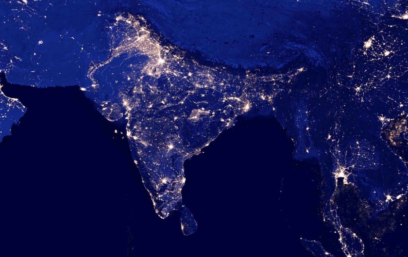
This new image of the Earth at night is a composite assembled from data acquired by the Suomi National Polar-orbiting Partnership (Suomi NPP) satellite over nine days in April 2012 and thirteen days in October 2012. It took 312 orbits and 2.5 terabytes of data to get a clear shot of every parcel of Earth’s land surface and islands.
දකුණු ආසියාවට ඉහළින් චන්ද්රිකා ගමන් කරද්දී 2012දී ගත් රාත්රි එළි චන්ද්රිකා ඡායාරූප ලෝක බැංකු පර්යේෂකයෝ සමීපව අධ්යයනය කර තිබෙනවා. මේ අනුව ඔවුන් සොයා ගත්තේ ප්රධාන හා අතුරු මාර්ග ඔස්සේ තීරු ලෙස ඒ දෙපසින් ටිකෙන් ටික නගර විහිද යන සැටියි (‘ribbon development’).
1999දී රාත්රී එළි අධ්යයනයෙන් පෙනී ගිය නාගරික ඒකරාශී වීම් 37ක් දකුණු ආසියාවේ තිබුණා. 2010 වනවිට එය 45 දක්වා වැඩිවී තිබෙනවා.
ශ්රී ලංකාවේ රාත්රී එළි අධ්යයනයෙන් පෙනී යන්නේ කොළඹ සිට සෙසු ප්රධාන නගරවලට විහිදෙන මාර්ග රැසක්ම දෙපස බෙහෙවින් නාගරීකරණය වී ඇති බවයි.
ශ්රී ලංකාවේ රාත්රී එළි කොළඹ හා තදාසන්න ප්රදේශවල වඩාත් ම ප්රබල අතර ඊළඟට වැඩියෙන් ම දීප්තියෙන් පෙනෙන්නේ යාපනය අර්ධද්වීපයයි. කොළඹට අමතරව මහනුවර, ගාල්ල, කුරුණෑගල වැනි ප්රධාන නගරවලත් රාත්රී ආලෝක පැහැදිලිව තිබෙනවා.
යාපනයට අමතරව වවුනියා, අනුරාධපුරය හා ත්රිකුණාමලය නගර මුල් කර ගෙන ආලෝක සංකේන්ද්රනයක් පෙනෙනවා. එසේ ම මඩකළපුව හා ආරුගම් බොක්ක ප්රදේශයේත් පැහැදිලි එළි රැසක් තිබෙනවා.
මහනුවර සිට යාපනයට දිවෙන කිමී 321ක් දිග A9 මහා මාර්ගයේ කොටස් රාත්රී එළි නිසා අභ්යවකාශයේ සිට හඳුනාගත හැකියි. අවට දෙපස අඳුරේ තිබියදී මහා මාර්ගය දෙපස පමණක් එළි පෙනෙනවා. මෙබඳු ප්රධාන මාර්ගවල විහිදීම දිවයිනේ වෙනත් ප්රදේශවලත් දිස් වනවා.
නගර කෙමෙන් පැතිරෙන්නේ මහාමාර්ග ඔස්සේයි. පෞද්ගලික දේපල හිමිකාරිත්වයට අවසර ඇති ඕනැම රටක මෙය සිදුවනවා.
6 January 2013: සිවුමංසල කොලූගැටයා #99: ලෝකෙට ම පෙනෙන අපේ රාත්රි එළි
චන්ද්රිකා දත්ත විග්රහයෙන් යා හැකි දුර සීමිතයි. නිසි නාගරික කළමනාකරණයට විස්තරාත්මක භූමි පරිභෝජන දත්ත මෙන්ම ජන චල්යතා දත්තද අවශ්යයි.
ශ්රී ලංකාවේ දැනට නාගරික යයි නිල වශයෙන් පිළිගන්නා ජනගහනයෙන් 48%ක්ම සිටින්නේ බස්නාහිර පළාතේ මහ නගර සභා බල ප්රදේශ අටකයි. ඒවා නම් කොළඹ, කඩුවෙල, දෙහිවල-ගල්කිස්ස, මොරටුව, කෝට්ටේ, කැස්බෑව, මහරගම හා මීගමුවයි. මේ අතරින් මීගමුව හැරුණු කොට අන් හතම අයත් කොළඹ දිස්ත්රික්කයටයි.
කොළඹ දිස්ත්රික්කයට මෙතරම් නාගරික ජන ප්රතිශතයක් හිමි වීමට හේතුව දැනට භාවිත කරන නිර්වචනයේ දෝෂයයි. එසේ නොමැතිව නාගරික ගතිගුණ ඇති ප්රදේශ අනෙක් දිස්ත්රික්කවල යහමින් නැතිවාට නොවේ.
See also:
28 April 2013: සිවුමංසල කොලූගැටයා #115: ගම හා නගරය අතර අතරමං වූ ලක් සමාජය
Census of Population and Housing 2012: Key Findings: http://goo.gl/Dij22Y
Leveraging Urbanization in South Asia: Managing Spatial Transformation for Prosperity and Livability (September 2015)
 Meanwhile, a new World Bank report on urban trends in South Asia reminds us that Sri Lanka’s share of the population officially classified as living in urban areas actually fell slightly between 2000 and 2010.
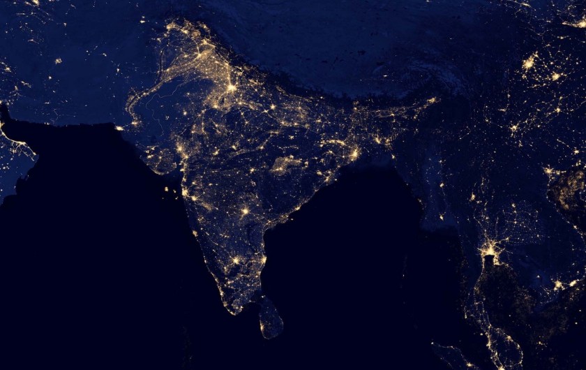
 For example,